
Current Presentations & Courses
Great Overland Journeys Around the World
Tuesdays 10:00 AM to 12:00 Noon - Online Class from October 28 to December 9, 2025 - Simon Fraser University (No class November 11)
Join Peter Langer on six amazing safaris, featuring breathtaking photography along with background information and expert advice such as how and when to visit, and how to make the most of a wildlife safari, as well learning about the various cultural groups that inhabit the region. Get useful tips on local food and shopping. This playful, informative mix of inspiring personal narratives and intriguing facts will appeal whether you are an active traveller or you simply dream of visiting far-flung destinations in this part of the world.
CONTENTS
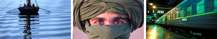
Weeks 1 and 2: Great Railway Journeys
Discover some of the great rail journeys around the world that combine the romance of slow travel with breathtaking scenery. We’ll experience the legendary Trans-Siberian Railway crossing the vast Russian landscape and the stunning views of the Alps offered by the Glacier Express and Benina Express in Switzerland. We’ll enjoy a virtual ride on the Darjeeling Himalayan Railway, an outstanding example of a World Heritage Railway on the Indian subcontinent, while on the African continent we’ll experience a vintage train ride on the Eritrean Railway, constructed between 1887 and 1932 by the Kingdom of Italy. In the Americas, we’ll take a virtual ride on the Chihuahua-Pacific Railway through the Copper Canyon located in the Sierra Madre Occidental, and then embark on train adventures in the Andes Mountains, including the Ecuadorian Railway winding through the dramatic Devil’s Nose, and the train to Machu Picchu that offers stunning views of the Sacred Valley of the Incas. .
Weeks 3 and 4: Great River Journeys
We will embark on three river cruises in these two classes, starting with a virtual journey from Budapest to Amsterdam by riverboat on the Danube, Main and Rhine rivers. Along the way we will explore castles, medieval monasteries and scenic wine-country landscapes, as well as many UNESCO World Heritage sites in Austria, Germany and the Netherlands. We will then take a virtual Nile cruise through the cradle of ancient civilization, exploring Egypt’s iconic landmarks and landscapes between Luxor and Aswan in a unique way, discovering majestic temples and ruins. We conclude with a virtual river cruise on Myanmar’s Irrawaddy River, from Bagan to Mandalay, revealing the country’s rich culture, timeless landscapes and ancient heritage. As we glide along the wide, golden waters of the river, we witness daily life unfolding along its banks—fishermen casting nets, farmers tending fields, and children waving from stilted villages.
Weeks 5 and 6: Great Road Journeys
We will experience some thrilling adventures through some of the world’s most breathtaking and remote landscapes. Winding through the towering peaks of the Himalayas, the Karakoram and other majestic ranges, these routes combine awe-inspiring scenery with cultural encounters. We start in the Hindu Kush, by travelling down the Khyber Pass from Peshawar in Pakistan to Kabul and Bamiyan in Afghanistan. We’ll then explore the legendary Karakoram Highway between Pakistan and China, take a journey from Leh in Ladakh to the Vale of Kashmir in northern India and embark on a journey along the Friendship Highway from Nepal to Tibet, across the “Roof of the World.” We will conclude in South America, travelling along the Pan-American Highway, the dramatic Death Road in Bolivia and Ruta 40, Argentina’s Patagonian Highway.
What You Will Learn
By the end of the course, you should be able to:
- Describe details of adventuresome railway trips, river cruises and road trips throughout the world
- Appreciate the incredible diversity offered by each of these journeys
- Get practical insights useful to potential travellers
.
How You Will Learn
- Participation in Zoom seminars
- Participation in written discussions with other students
- Supplementary resources accessed through Canvas
- Reflective essay (applicable only to certificate students)
______________________________________________________________________________________________
Remarkable Cities of the World
Thursdays 10:00 AM to 12:00 Noon - Online Class from October 30 to December 4, 2025 - Simon Fraser University
Join us for six virtual adventures through some of the world’s most remarkable cities. We’ll explore stunning urban landscapes; learn about the UNESCO World Heritage sites they contain; and discover an amazing diversity of peoples and cultures. Each week we will view a multi-image presentation that evokes the incredible beauty of each city. We’ll discuss sightseeing highlights, curious anecdotes and some of the secrets each place has to offer. Potential travellers to these cities will gain a useful, deeper understanding of their subtleties.
CONTENTS
Week 1: Berlin
We’re off to Germany to explore Berlin, one of Europe’s most dynamic and historically rich cities. Our virtual tour takes us through Berlin’s dramatic past—from the rise and fall of the Berlin Wall to the city’s vibrant rebirth as a capital of culture, creativity and resilience. Home to three UNESCO World Heritage sites, the city features stunning visuals and iconic landmarks like the Brandenburg Gate, the Reichstag and remnants of the Wall, alongside modern neighbourhoods teeming with street art, cafés and cutting-edge architecture. We’ll delve into Berlin’s diverse cultural scene, world-class museums and poignant memorials, offering insights into how history, innovation and multiculturalism shape the city’s unique identity today.
Week 2: Venice
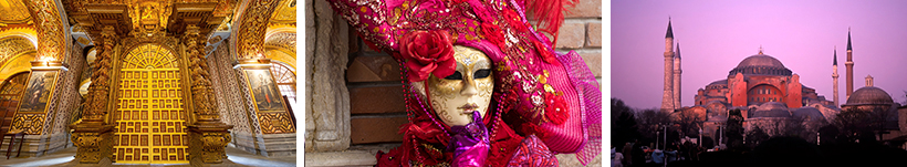
Italy’s Venice became a major maritime power in the 10th century. Venice (and its lagoon) is registered on the UNESCO World Heritage list, as the whole city is an extraordinary architectural masterpiece in which even the smallest building contains works by some of the world's greatest artists. And while the city is suffering from over-tourism, it has not lost any of its beauty and charm. We will also learn about the Carnival of Venice, famous throughout the world for its elaborate costumes and masks. The Carnival traces its origins to the Middle Ages, existing for several centuries until it was abolished in 1797, but revived in 1979.
Week 3: Istanbul
This week we focus on Istanbul, Türkiye, taking a fascinating look at a city that bridges two continents and countless centuries of history. We’ll journey through the rich tapestry of empires—Byzantine, Roman and Ottoman—that have shaped the city’s unique identity. The Historic Areas of Istanbul, registered as a UNESCO World Heritage site, features iconic landmarks such as Hagia Sophia, the Blue Mosque and Topkapi Palace. The bustling Grand Bazaar and spice-scented markets reflect Istanbul’s vibrant daily rhythm.
Week 4: Delhi
Delhi in India is one of the world’s oldest and most vibrant capitals—a city where ancient history and modern life intertwine and the home to three UNESCO World Heritage sites. We’ll explore the contrasts of Old and New Delhi, from the bustling bazaars and Mughal monuments like the Red Fort and Jama Masjid, to the wide boulevards and colonial architecture of Lutyens’ Delhi. Rich visuals and storytelling bring to life the city’s layered past, spiritual diversity and dynamic street culture. We’ll gain insight into Delhi’s role as a political, cultural and culinary heart of India, where centuries of tradition meet the energy of a rapidly evolving metropolis.
Week 5: Mexico City
Discover one of the oldest cities in the Americas. Mexico City boasts four UNESCO World Heritage Sites and more than 650 museums that appeal to all interests and tastes: from the renowned Museum of Anthropology to the various buildings proudly displaying the extraordinary murals by Diego Rivera, José Clemente Orozco and David Alfaro Siqueiros. We will also explore the canals and floating gardens of Xochimilco, as well as one of the most powerful cultural centres in Mesoamerica, the Pre-Hispanic city of Teotihuacan.
Week 6: Quito
Often overlooked on the way to explore the Galapagos Islands, we’ll visit Quito, the capital of Ecuador, with its dramatic setting surrounded by volcanic peaks. Despite an earthquake in 1917, the city has the best-preserved, least-altered historic centre in Latin America. This UNESCO World Heritage Site features ornate churches, cobblestone plazas and vibrant markets. We’ll delve into Quito’s Indigenous roots and Spanish colonial influence, offering a vivid portrait of a city where tradition and modernity meet at the top of the world.
What You Will Learn
By the end of the course, you should be able to:
- Describe ways in which history, tradition and modernity intertwine to create the vibrancy of these cities
- Identify several UNESCO World Heritage sites within these cities
- Appreciate the incredible diversity within each of these remarkable cities
- Get insights useful to travellers
How You Will Learn
- Participation in Zoom seminars
- Participation in written discussions with other students
- Supplementary resources accessed through Canvas
- Reflective essay (applicable only to certificate students)
______________________________________________________________________________________________
2026 Presentations & Courses
Islands & Archipelagos - The Nature • The People • The Heritage
Thursdays 10:00 AM to 12:00 Noon - Online Class from January 15 to February 19, 2026 - Simon Fraser University
Join Peter Langer and larn about some of our planet’s most remote islands and archipelagos from the Arctic to Antarctica. Discover a host of unique cultures that inhabit many islands of the world, as island people are often isolated from mainlanders and from one another by the sea.
CONTENTS
Week 1: Arctic Ocean Islands
Starting in Canada, we explore some remote locations on Baffin Island, seabird colonies in Digges Island and get close-up views of walruses and polar bears at Walrus Island in Nunavut Territory. Visit then discover Disko Bay, Qeqertarsuaq and the Ilulissat Icefjord on Greenland’s West coast, and Scoresby Sound on Greenland’s East coast. We conclude in Svalbard, formerly called Spitzbergen, a Norwegian archipelago situated about midway between the northern coast of Norway and the North Pole.
Week 2: Islands around Europe
In the North Atlantic Ocean, we explore Iceland, where we will see Reykjavík and Þingvellir National Park where the oldest parliament in the world, met regularly from 930 to 1798. Marvel at Iceland’s many waterfalls and the geysers of Geysir and the Vestmannaeyjar Archipelago, We then head to the Eastern Mediterranean to visit Cyprus, where we will explore Nicosia, Famagusta, Choirokoitia and the Painted Churches in the Troodos Region. We conclude in Malta, discovering some ancient neolithic sites such as Hagar Qim and Mnajdra. We the explore the capital Valletta and the historical city of Mdina and the island of Gozo.
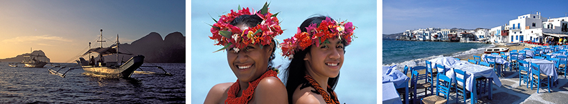
Weeks 3 and 4: Indian Ocean Islands
We start our Indian Ocean journey on the island of Zanzibar, one of the most important Swahili coastal trading towns of East Africa. We then head to Madagascar, often referred to as the “Eighth Continent”. The island’s legendary uniqueness is best reflected by its plethora of amazing lemurs, colourful chameleons, many endemic bird species, and a fascinating array of endemic flora, all of which combine to make for a truly exceptional photo safari. We then head to Mauritius, an island featuring unique cultural landscapes and Rodrigues, a volcanic island rising from the Mascarene Plateau. We conclude in Sri Lanka, an island country that features ancient Buddhist monuments, welcoming people, dense jungle, cool highlands and idyllic tropical coast. We will explore Colombo, the UNESCO World Heritage Sites of Anuradhapura, Polonnaruwa, Sigiriya, Dambulla and Kandy. We then head to the verdant highlands of Nuwara Eliya, home of some beautiful tea plantations. We then explore the Old Town of Galle and its Fortifications, which illustrates the interaction of European architecture and South Asian traditions.
Weeks 5 and 6: Islands of the Coasts of South America & Antarctica
We begin with a visit to the San Blas Islands of Panama, a haven for ecotourism because of its pristine environs along the Caribbean coast of Panama. We then travel to the notorious prisons of Devil’s Island off the coast of French Guiana. Then we see the amazing natural wonders and unusual animal life of the Galapagos Islands, followed by a visit to the archaeological remains on Rapa Nui, the indigenous name of Easter Island, and see the enormous stone figures known as moai, which created a unique cultural landscape that continues to fascinate people throughout the world. We then head to the remote landscapes of Tierra del Fuego and Cape Horn in Patagonia, the Diego Ramirez Islands, South Georgia and the South Shetland Islands in the Southern Ocean surrounding Antarctica.
What You Will Learn
By the end of the course, you should be able to:
- Outline some of our planets most important islands.
- Identify different kinds of island habitats around the globe.
- Get insights about unusual places
- Receive and accurate travel information.
.
How You Will Learn
- Participation in Zoom seminars
- Enjoy stunning multi-image musical video presentations
- Participation in written discussions with other students
- Supplementary resources accessed through Canvas
- Reflective essay (applicable only to certificate students)
______________________________________________________________________________________________
Remarkable Cities of the World - Part 2
Tuesdays 10:00 AM to 12:00 Noon - Online Class from January 13 to February 17 2026 - Simon Fraser University
Join us for six virtual adventures through more of the world’s most remarkable cities. We’ll explore stunning urban landscapes; learn about the UNESCO World Heritage sites they contain; and discover an amazing diversity of peoples and cultures. Each week we will view a multi-image presentation that evokes the incredible beauty of each city. We’ll discuss sightseeing highlights, curious anecdotes and some of the secrets each place has to offer. Potential travellers to these cities will gain a useful, deeper understanding of their subtleties.
CONTENTS
Week 1: Barcelona, Spain
We explore Barcelona, the capital and largest city of Catalonia and Spain's second largest city,
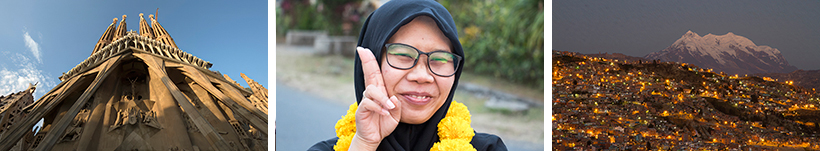
This city, located directly on the northeastern Mediterranean coast of Spain, features a has a rich history since Carthaginian times. We wonder around the Ciutat Vella featuring one the best-preserved Gothic quarters in Europe. We will also the whimsical architecture created by Antoni Gaudí and Lluís Domènech i Montaner, which have been designated UNESCO World Heritage Sites.
Week 2: Esfahan, Iran
Esfahan is known for its Persian–Muslim architecture, grand boulevards, covered bridges, palaces, tiled mosques, and minarets. We will discover “Half the World” as we enjoy the beauty of Persian Gardens, admire masterpieces of Islamic architecture, amazing bazaars and stunning Armenian churches located in the city . Along the way you will discover the real Iran, home of a warm and fascinating people living within an ancient and sophisticated culture.
Week 3: Hanoi, Vietnam
The speed with which Vietnam has been able to transcend the recent past comes as a surprise to visitors who visit its capital, Hanoi. The city is alternately bustling and tranquil, and its food is a destination unto itself. We will visit Ho Chi Minh’s house, the lotus-shaped One Pillar Pagoda, and the Temple of Literature, Hanoi’s first university. We will wonder around Hanoi’s Old Quarter and watch a traditional water puppet show. We will explore the Central Sector of the Imperial Citadel of Thang Long, a UNESCO World Heritage Site and the nearby World Heritage sites of Ha Long Bay and the Trang An Landscape Complex.
Week 4: Yogyakarta, Indonesia
As the only Indonesian royal city still ruled by a monarchy, Yogyakarta is regarded as an important centre for classical Javanese fine arts and culture such as batik textiles, gamelan music visual arts, and wayang puppetry. Here we will explore the UNESCO World Heritage Sites of Borobudur and ancient Buddhist temple, dating from the 8th and 9th centuries, the Hindu Prambanan Temple Compounds, The Cosmological Axis of Yogyakarta and its Historic Landmarks and the nearby Sangiran Early Man Site.
Week 5: La Paz, Bolivia
La Paz is the highest capital city in the world. While three centuries of Spanish colonial rule have left their mark on Bolivia's language, religion and architecture, this European influence is no more than a thin veneer overlying Indigenous cultural traditions that stretch back to long before the conquest. We will also explore Sacred Lake Titicaca, the highest navigable lake in the world; the city of Tiwanaku, capital of a powerful pre-Hispanic empire that dominated a large area of the southern Andes between 500 and 900 CE and the Salar de Uyuni the largest salt flat (dry lake bed) in the world.
Week 6: Santiago, Chile
Founded in 1541 by the Spanish conquistador Pedro de Valdivia, Santiago has served as the capital city of Chile since colonial times. We explore the downtown core characterized by 19th-century neoclassical architecture and winding side streets with a mix of Art Deco, Gothic Revival, and other styles. Santiago's cityscape is defined by several standalone hills and the fast-flowing Mapocho River, which starts high up in the Andes Mountains, which are visible from most parts of the city. We will discover renowned vineyards and the nearby UNESCO World Heritage Site of the Historic Quarter of the Seaport City of Valparaíso.
What You Will Learn
By the end of the course, you should be able to:
- Describe ways in which history, tradition and modernity intertwine to create the vibrancy of these cities
- Identify several UNESCO World Heritage sites within these cities
- Appreciate the incredible diversity within each of these remarkable cities
- Get insights useful to travellers
How You Will Learn
- Participation in Zoom seminars
- Enjoy stunning multi-image musical video presentations
- Participation in written discussions with other students
- Supplementary resources accessed through Canvas
- Reflective essay (applicable only to certificate students)